Tickets
English
USD
Language
Currency
Contents

Your guide to traveling from rim to rim at the Grand Canyon

Spanning 277 miles and carved over millions of years, the Grand Canyon isn’t just one destination—it’s a landscape of contrasts. From the popular South Rim to the remote North Rim and the activity-packed West Rim, each side offers something different.

This page is your guide to exploring the Grand Canyon Rim to Rim—how to get from one side to another, what to expect during each season, and how to plan a trip that connects the Canyon’s diverse views, trails, and experiences. Whether you’re driving, hiking, or taking a tour, you’ll find everything you need here.

Grand Canyon map: Understanding the Rims

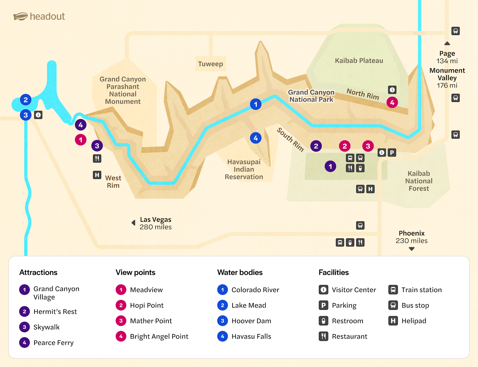
Before planning a Rim to Rim hike, it is important to get your bearings. There are three main Rims:

  • South Rim: This is the most popular of the three, as it is open year-round and is easily accessible.
  • North Rim: It is open seasonally, from mid-May to mid-October, and is higher in elevation. It is a lot quieter.
  • West Rim: It is run by the Hualapai Tribe and is home to the 10-foot wide and 70-feet out Skywalk. It is closest to Las Vegas, a 2-hour drive.

These rims are not directly connected. The South and North Rims are about 21 miles apart as the crow flies, but driving between them takes about 4.5 hours (215 miles). The West Rim is about 4 hours (250 miles) from the South Rim, and much farther from the North Rim.

How to travel between the Rims

Traveling across the Grand Canyon isn’t as simple as it may look on a map. Roads loop around deep canyons, and some rims are only seasonally accessible. Here's how you can travel between the West, South, and North Rims—by car, train, trail, or tour.

West Rim to South Rim

Distance: ~250 miles

  • By car
    Route: Take Pierce Ferry Rd to US-93 S, then I-40 E, and finally AZ-64 N to reach the South Rim via Tusayan.
    Travel time: 4–4.5 hours
  • By train: There is no direct train but you can catch a train from Williams, AZ (65-mile drive from the West Rim) and board the Grand Canyon Railway to the South Rim.
  • By hike: This is not an option since there are no connecting trails between the two rims.

Notes: Since the West Rim is not part of Grand Canyon National Park, separate entry fees and rules apply. This is also why there are no shuttle services available between the two.

South Rim to North Rim

Distance: ~215 miles by road and ~21 miles by trail

  • By car
    Route: Head east on AZ-64 to US-89 N, then turn west onto AZ-67 S to reach the North Rim.
    Travel time: 4.5–5 hours
    Stops along the way: Cameron Trading Post, Marble Canyon / Navajo Bridge, and Jacob Lake Lodge (good for food & fuel)
  • By hiking
    Route: South Kaibab or Bright Angel Trail → Phantom Ranch → North Kaibab Trail
    Distance: 21–24 miles
    Hike time: 1–3 days, depending on pace and overnight stays.
    Notes: Overnight stays require a permit, and the North Rim is closed from mid-October to mid-May due to snowfall.
  • By train: Unavailable; the train services only the South Rim.
  • By shuttle: Trans-Canyon Shuttle is available; a reservation is required.

North Rim to West Rim

Distance: ~275–300 miles

  • By car
    Route: Drive north via AZ-67, then west through Fredonia, across the Arizona Strip, and south toward Meadview and the West Rim.
    Travel time: 5.5–6 hours
    Notes: Roads are remote and services are limited—plan fuel stops carefully
  • By train/hike: Services unavailable

Pro tip: Since North Rim is seasonal and the Hualapai Tribe operates West Rim, check both areas’ official sites for real-time access info before making plans.

Book Rim to Rim Tours

0

Seasonal considerations if you’re going Rim to Rim

Operating months

  • North Rim
    Open: Mid-May to mid-October
    It is closed during the winter months (December–May) due to heavy snowfall, and roads and visitor services are unavailable.
  • South Rim
    Open: All year-round
    It remains accessible throughout the year, with well-paved roads and functional visitor centers. However, snow and ice can still affect hiking trails, so research is a must.
  • West Rim
    Open: All year-round
    Since it is not a part of the National Park, a separate entrance fee is applicable. It is open from 8am–6pm, with the last entry at 5pm.

Weather difference between Rims

  • North Rim: The North Rim sits at over 8,000 feet in elevation, making it cooler and more lush than the other rims. Its alpine forests, meadows, and quieter atmosphere offer a completely different Grand Canyon experience.
  • South Rim: The South Rim is slightly lower in elevation and warmer than the North Rim, making it accessible year-round. It’s the most developed section of the park, with visitor centers, shuttle buses, and a wide range of services and accommodations.
  • West Rim: The West Rim lies at the lowest elevation of the three, which means it gets hot, especially in summer. It’s not part of Grand Canyon National Park but is managed by the Hualapai Tribe. The landscape is more arid, with fewer hiking trails.

Trail conditions

  • North Rim: Summers are ideal; fall is crisp and dry, and winters are inaccessible due to heavy snowfall.
  • South Rim: Summers are brutally hot; winters may bring ice and snow-covered trails (especially at the top), and monsoons can get muddy, with flash floods.
  • West Rim: Summers are very hot with limited shade; winters are dry and accessible; and monsoons turn the ground slick and muddy.

Essentials to plan your Rim to Rim adventure

Planning a Rim-to-Rim adventure isn’t just about stamina—it’s about smart preparation. Here’s what you need to know before you lace up those boots.

Best time to plan your adventure

Due to heavy snowfall and winter closures, the North Rim is only open from mid-May to mid-October, so your window for Rim-to-Rim is limited. The South Rim is open year-round, but summer heat in the inner canyon can be dangerous.

  • Late May to early June: Mild temperatures, fewer crowds.
  • September to early October: Cooler temperatures and clearer skies—ideal for long-distance hiking.
  • July to August: Extremely hot in the inner canyon (often 100°F+ / 38°C+), and thunderstorms can cause flash floods. Only attempt if you’re experienced and well-prepared.

☀️ Avoid the hottest part of the day (10am–4pm) if you’re hiking in summer.

Lodging options

You’ll need a bed at both ends of your hike, and those fill up fast—book 6–12 months in advance where possible.

🏕️ Backcountry camping permits are required if you plan to stay overnight below the rim.

Shuttle logistics

  • Trans-Canyon Shuttle: Runs daily between the South and North Rim (mid-May to mid-October). Reservations are a must (they open one year in advance)
    Price: $120 per seat
    Travel time: 5.5 hours

No shuttle service is available to the West Rim since the area is managed separately by the Hualapai Tribe.

🚌 There’s no public transportation between the Rims.

Acclimatization and altitude tips

The North Rim is over 8,000 feet (2,438 m) high, and altitude sickness is a real concern for many hikers, especially those coming from lower elevations.

  • Spend a night at the rim before starting your hike to give your body time to adjust.
  • Symptoms of altitude sickness include headaches, nausea, and dizziness. Don’t ignore them.

🫁 Even if you’re fit, altitude can hit unexpectedly. Hydration and rest help.

Trail safety and hiking rules

  • Rim-to-Rim is no casual stroll—it’s a demanding hike that stretches 20 to 24 miles, depending on your chosen route, with steep elevation changes and rapidly shifting temperatures. 
  • Conditions in the inner canyon can be drastically different from those at the rim, with temperature swings of 30°F or more. Water sources are limited and sometimes seasonal, so it’s important to carry at least 3–4 liters of water and know where refill stations are located. 
  • Bring high-energy snacks, sun protection, and a headlamp if there’s any chance you’ll be hiking in low light. 
  • Emergencies are not uncommon, and cell service is spotty at best, so consider carrying a GPS communicator. 
  • Stick to marked trails, pack out all trash (yes, even food scraps), and never feed wildlife. 
  • Following Leave No Trace principles helps protect the canyon for future adventurers and keeps you safe.


Frequently asked questions about travelling from Rim to Rim in the Grand Canyon

Where should I begin my Rim to Rim hike?

Most hikers start from the North Rim and descend via the North Kaibab Trail, ending at the South Rim. It's a net downhill and opens earlier in the day to shade. But starting from the South is just as doable—just expect a steeper climb on the way out.

Can kids or seniors do a Rim-to-Rim hike?

Yes, but only if they’re physically prepared and have some experience with canyon hiking. It’s a challenging trek with steep elevation changes and heat exposure. A great way to build up is by starting with shorter canyon hikes, like the Bright Angel Trail to Indian Garden (4.5 miles one-way) or the South Kaibab Trail to Cedar Ridge (1.5 miles one-way).

What’s the elevation change like?

You’ll descend and climb between 4,500 and 6,000 feet, depending on your direction. It’s no casual stroll—expect steep switchbacks and long stretches of exposed trail.

How can I acclimate for the hike?

Arrive a couple of days early to adjust to the altitude, especially if you’re starting at the North Rim. Do short hikes, hydrate well, and avoid overexerting yourself too soon.

How long does a Rim to Rim hike take?

One to three days is typical. Some attempt it in a single day, but that requires top fitness, perfect weather, and an early start. If in doubt, spread it out.

Do I require a permit for the hike?

Only if you’re camping overnight in the canyon. Day hikes don’t need a permit, but overnight trips require a backcountry permit from the National Park Service.

Are there bathrooms and water stops along the trail?

Yes, but not at every turn. Facilities are located at key points like Phantom Ranch and trail junctions, but some water stations are seasonal. Always inquire about trail conditions before planning or heading out.

Can I do it solo?

Yes, but you need to be extra cautious. Share your plan, carry a GPS or satellite beacon, and be well-prepared for emergencies. Solitude can be amazing—just don’t let it catch you off guard.

What should I pack for a Rim-to-Rim hike?

Water (lots), salty snacks, sun protection, a wide-brimmed hat, layers for chilly mornings and hot afternoons, a map, blister care, trash bags, and a sense of adventure. The canyon demands respect—and good socks.

More reads

Camping

Plan your visit

Wildlife